
Voorburg topographic map
Interactive map
Click on the map to display elevation.
About this map
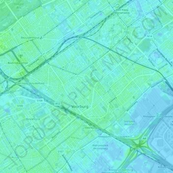
Name: Voorburg topographic map, elevation, terrain.
Location: Voorburg, Leidschendam-Voorburg, Südholland, Niederlande (52.05650 4.33521 52.09230 4.39154)
Average elevation: 3 m
Minimum elevation: -4 m
Maximum elevation: 8 m
Other topographic maps
Click on a map to view its topography, its elevation and its terrain.
Leidschendam-Voorburg
Niederlande > Südholland > Leidschendam-Voorburg
Leidschendam-Voorburg, Südholland, Niederlande
Average elevation: 0 m