
Make a donation
Gear up for your next adventure:
As an Amazon Associate, this site earns from qualifying purchases at no extra cost to you.
Col du Glandon topographic map
Click on the map to display elevation.
Make a donation
Gear up for your next adventure:
As an Amazon Associate, this site earns from qualifying purchases at no extra cost to you.
About this map
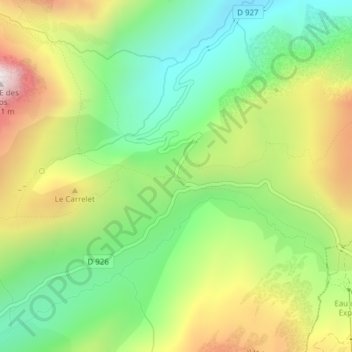
Name: Col du Glandon topographic map, elevation, terrain.
Average elevation: 1,939 m
Minimum elevation: 1,568 m
Maximum elevation: 2,486 m
Make a donation
Gear up for your next adventure:
As an Amazon Associate, this site earns from qualifying purchases at no extra cost to you.
Other topographic maps
Click on a map to view its topography, its elevation and its terrain.
Saint-Colomban-des-Villards
Frankrijk > Auvergne-Rhône-Alpes > Savoie > Saint-Colomban-des-Villards
Het winterseizoen is minder rigoureus dan elders in het Mauriennedal. Wanneer er daar in de herst en in de winter dikwijls mistvorming ontstaat, kan het weersgesteldheid in Saint-Colomban voortreffelijk zonnig zijn. Afgezien van de vele zonuren, valt er gemiddeld wel meer sneeuw in Saint-Colomban dan elders in…
Average elevation: 1,801 m