Geolocate

Loredo topographic map

Click on the map to display elevation.

Loredo

La localidad está situada a 20 metros de altitud sobre el nivel del mar y a 6,5 kilómetros de la capital municipal, Carriazo. En 2008 contaba con una población de 709 habitantes (INE).

Wikipedia (CC-BY-SA 3.0)

About this map

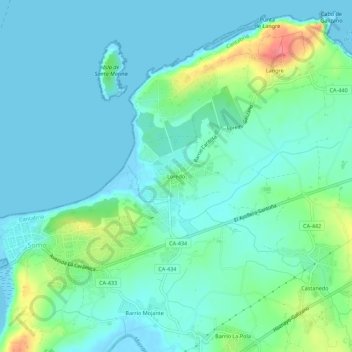
Name: Loredo topographic map, elevation, terrain.

Location: Loredo, Ribamontán al Mar, Cantabria, 39160, España (43.44128 -3.73962 43.48128 -3.69962)

Average elevation: 15 m

Minimum elevation: -3 m

Maximum elevation: 70 m

Other topographic maps

Click on a map to view its topography, its elevation and its terrain.

Playa de Loredo

España > Cantabria > Ribamontán al Mar > Somo > Loredo

Average elevation: 12 m

Gear up for your next adventure:

🦌Outdoor Trail Camera - Monitor wildlife activity near your favorite spots
Camping Groundsheet - Protect your tent from moisture and dirt
🧦Thermal Socks - Warm socks for winter hiking or camping
🍽️Titanium Camping Spork - Ultralight and indestructible eating utensil
🛌Insulated Sleeping Pad - Critical thermal barrier between you and the cold ground

As an Amazon Associate, this site earns from qualifying purchases at no extra cost to you.