Geolocate

Coin topographic map

Click on the map to display elevation.

About this map

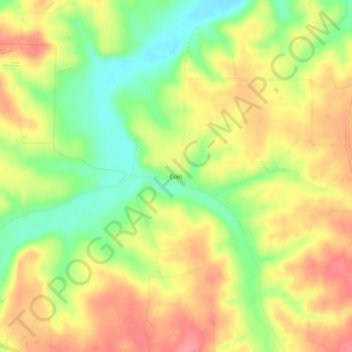
Name: Coin topographic map, elevation, terrain.

Location: Coin, Carroll County, Arkansas, United States (36.31035 -93.36796 36.35035 -93.32796)

Average elevation: 368 m

Minimum elevation: 323 m

Maximum elevation: 407 m

Gear up for your next adventure:

🩹Moleskin Blister Pads - Direct protection for painful foot pressure points
🌡️Emergency Mylar Blankets - Compact thermal protection for unexpected nights outdoors
🧥Waterproof Hiking Jacket - Protect yourself from rain and wind while hiking
🧣Merino Neck Gaiter - Protects against wind, sun, and cold at high altitudes
🧥Thermal Layer - Insulating layer for cold outdoor conditions

As an Amazon Associate, this site earns from qualifying purchases at no extra cost to you.