Geolocate

Udine topographic map

Click on the map to display elevation.

About this map

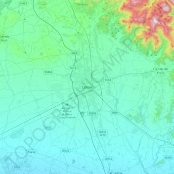
Name: Udine topographic map, elevation, terrain.

Location: Udine, Friuli-Venezia Giulia, 33100, Italy (45.90346 13.07584 46.22346 13.39584)

Average elevation: 152 m

Minimum elevation: 15 m

Maximum elevation: 1,144 m

Other topographic maps

Click on a map to view its topography, its elevation and its terrain.

Porta Manin

Italy > Friuli-Venezia Giulia > Udine > Udine

Average elevation: 114 m

Gear up for your next adventure:

🧭GPS Handheld Device - Reliable GPS navigation for outdoor adventures
🥾Light Trekking Boots - Supportive boots for multi-day treks
🧢Outdoor Visor - Breathable visor for sunny hikes
🛶Kayak Accessories - Essential gear for safe and fun kayaking adventures
🧥Waterproof Hiking Jacket - Protect yourself from rain and wind while hiking

As an Amazon Associate, this site earns from qualifying purchases at no extra cost to you.