Geolocate

Zambrana topographic map

Click on the map to display elevation.

About this map

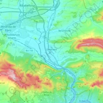
Name: Zambrana topographic map, elevation, terrain.

Location: Zambrana, Cuadrilla de Añana, Álava, País Vasco, España (42.63152 -2.90012 42.68566 -2.73760)

Average elevation: 558 m

Minimum elevation: 441 m

Maximum elevation: 949 m

Gear up for your next adventure:

🛰️Satellite Messenger - Emergency communication for areas with no cell service
Lightweight Backpacking Tent - Compact tent for efficient hiking trips
🧥Thermal Layer - Insulating layer for cold outdoor conditions
🧳Compression Sacks - Maximize space in your backpack by shrinking gear
💧Hydration Bladder - Hands-free hydration solution for long treks

As an Amazon Associate, this site earns from qualifying purchases at no extra cost to you.