Geolocate

Canelos topographic map

Click on the map to display elevation.

About this map

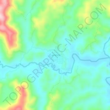
Name: Canelos topographic map, elevation, terrain.

Location: Canelos, Santa Rosa del Sur, Bolívar, Colombia (7.86222 -74.26006 7.90222 -74.22006)

Average elevation: 1,081 m

Minimum elevation: 1,006 m

Maximum elevation: 1,274 m

Other topographic maps

Click on a map to view its topography, its elevation and its terrain.

Caracoli

Colombia > Bolívar > Santa Rosa del Sur

Average elevation: 774 m

Gear up for your next adventure:

🔦LED Headlamp - Hands-free lighting for early morning starts or late finishes
🧥Softshell Hiking Jacket - The perfect balance of wind protection and breathability
🪑Ultralight Camping Stool - Compact seating for rest stops during long hikes
🌡️Emergency Mylar Blankets - Compact thermal protection for unexpected nights outdoors
🥾Light Trekking Boots - Supportive boots for multi-day treks

As an Amazon Associate, this site earns from qualifying purchases at no extra cost to you.