
Make a donation
Gear up for your next adventure:
As an Amazon Associate, this site earns from qualifying purchases at no extra cost to you.
Stöpgeshof topographic map
Click on the map to display elevation.
Make a donation
Gear up for your next adventure:
As an Amazon Associate, this site earns from qualifying purchases at no extra cost to you.
Stöpgeshof
Um 1590 wird der Ort erstmals unter der Bezeichnung „Stopgens Hove“ in einem Erbenregister der katholischen Kirchengemeinde Wipperfürth genannt. Die Karte Topographia Ducatus Montani aus dem Jahre 1715 zeigt einen Hof und bezeichnet diesen mit „Stopgeshof“. Die Topographische Aufnahme der Rheinlande von 1825 zeigt auf umgrenztem Hofraum Stöpgeshof mit drei getrennt voneinander liegenden Grundrissen.
Make a donation
Gear up for your next adventure:
As an Amazon Associate, this site earns from qualifying purchases at no extra cost to you.
About this map
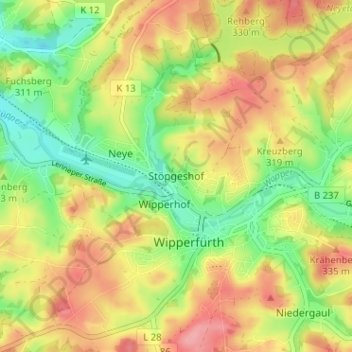
Name: Stöpgeshof topographic map, elevation, terrain.
Average elevation: 303 m
Minimum elevation: 254 m
Maximum elevation: 351 m
Make a donation
Gear up for your next adventure:
As an Amazon Associate, this site earns from qualifying purchases at no extra cost to you.
Other topographic maps
Click on a map to view its topography, its elevation and its terrain.
51688
Deutschland > Nordrhein-Westfalen > Oberbergischer Kreis > Wipperfürth > Lendringhausen
Average elevation: 322 m
Neyetalsperre
Deutschland > Nordrhein-Westfalen > Oberbergischer Kreis > Wipperfürth > Hönnige
Average elevation: 328 m