
Make a donation
Gear up for your next adventure:
As an Amazon Associate, this site earns from qualifying purchases at no extra cost to you.
Zemun topographic map
Click on the map to display elevation.
Make a donation
Gear up for your next adventure:
As an Amazon Associate, this site earns from qualifying purchases at no extra cost to you.
Zemun
One of the characteristics of the Zemun's topography are the lagums, artificial underground corridors which crisscross below the loess area of Gardoš, Muhar, Ćukovac and Kalvarija. This terrain is one of the most active landslide areas in Belgrade. Being cut into for centuries, the loess in some sections have cliffs vertical up to 90%. The Romans began digging the lagums at least as early as 1,700 years ago, using them mostly as the food storages, but later were also used for supply and eventual hiding and evacuation. In the previous centuries, settlers left many vertical shafts which ventilated the lagums, drying the loess and keeping it compact.
Make a donation
Gear up for your next adventure:
As an Amazon Associate, this site earns from qualifying purchases at no extra cost to you.
About this map
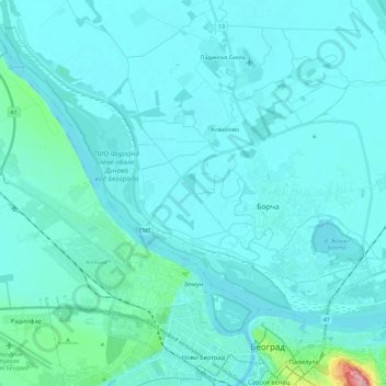
Name: Zemun topographic map, elevation, terrain.
Average elevation: 80 m
Minimum elevation: 65 m
Maximum elevation: 252 m
Make a donation
Gear up for your next adventure:
As an Amazon Associate, this site earns from qualifying purchases at no extra cost to you.