Geolocate

Demorest topographic map

Click on the map to display elevation.

About this map

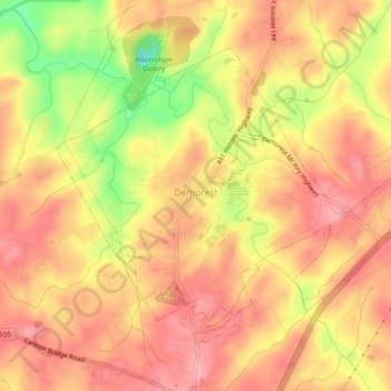
Name: Demorest topographic map, elevation, terrain.

Location: Demorest, Habersham County, Georgia, United States (34.55048 -83.56181 34.57932 -83.51570)

Average elevation: 416 m

Minimum elevation: 337 m

Maximum elevation: 455 m

Other topographic maps

Click on a map to view its topography, its elevation and its terrain.

Turnerville

United States > Georgia > Habersham County

Average elevation: 463 m

Habersham

United States > Georgia > Habersham County

Average elevation: 409 m

Batesville

United States > Georgia > Habersham County

Average elevation: 534 m

Gear up for your next adventure:

💧Reusable Water Bottle - Durable water bottles for hydration on trails
🔭Compact Monocular - One-handed bird watching and trail spotting
🧢Hiking Sun Hat - Wide-brimmed protection for exposed mountain ridges
Family Camping Tent - Spacious tent suitable for family camping trips
🩹Compact First Aid Kit - Pre-packed essentials for common trail injuries

As an Amazon Associate, this site earns from qualifying purchases at no extra cost to you.