Geolocate

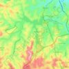
Parque Riachuelo topographic map

Click on the map to display elevation.

About this map

Name: Parque Riachuelo topographic map, elevation, terrain.

Location: Parque Riachuelo, Aparecida, Regional Noroeste, Belo Horizonte, Minas Gerais, Southeast Region, 31250-160, Brazil (-19.91080 -43.97261 -19.87080 -43.93261)

Average elevation: 854 m

Minimum elevation: 786 m

Maximum elevation: 939 m

Other topographic maps

Click on a map to view its topography, its elevation and its terrain.
Pampulha

Brazil > Minas Gerais > Belo Horizonte

Average elevation: 835 m

Gear up for your next adventure:

🔨Vehicle Emergency Tool - Safety tool for remote road trips to trailheads
🥾Trail Hiking Boots - Supportive boots for rough trails
🧴Bear Spray Holster - Quick-access carry for essential Canadian wilderness safety
⛺Lightweight Backpacking Tent - Compact tent for efficient hiking trips
🦟Insect Repellent - Keep mosquitoes and black flies away in wooded areas

As an Amazon Associate, this site earns from qualifying purchases at no extra cost to you.