Geolocate

Pampulha topographic map

Click on the map to display elevation.

About this map
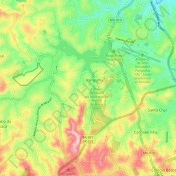
Name: Pampulha topographic map, elevation, terrain.

Location: Pampulha, Belo Horizonte, Minas Gerais, Southeast Region, Brazil (-19.90994 -44.02221 -19.82576 -43.92743)

Average elevation: 835 m

Minimum elevation: 738 m

Maximum elevation: 970 m

Other topographic maps

Click on a map to view its topography, its elevation and its terrain.
Parque Riachuelo

Brazil > Minas Gerais > Belo Horizonte

Average elevation: 854 m

Gear up for your next adventure:

🧢Beanie Hat - Keep your head warm in cold weather
🧥Softshell Hiking Jacket - The perfect balance of wind protection and breathability
🔭Compact Monocular - One-handed bird watching and trail spotting
🔥Emergency Fire Starter - Reliable ignition source for all weather conditions
🩹Moleskin Blister Pads - Direct protection for painful foot pressure points

As an Amazon Associate, this site earns from qualifying purchases at no extra cost to you.