Geolocate

Bigfork topographic map

Click on the map to display elevation.

About this map

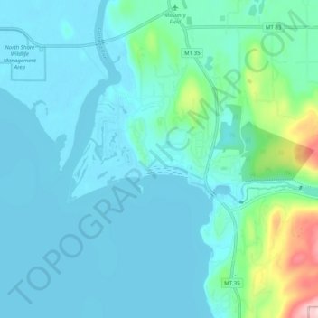
Name: Bigfork topographic map, elevation, terrain.

Location: Bigfork, Flathead County, Montana, United States (48.03681 -114.12811 48.09925 -114.02895)

Average elevation: 922 m

Minimum elevation: 879 m

Maximum elevation: 1,187 m

Gear up for your next adventure:

🦌Outdoor Trail Camera - Monitor wildlife activity near your favorite spots
Lightweight Backpacking Tent - Compact tent for efficient hiking trips
🧢Sun Hat - Wide-brim hat for sun protection
🛶Kayak Dry Bag - Waterproof storage for kayaking adventures
🏕️Camping Hammock - Integrated protection for sleeping between trees

As an Amazon Associate, this site earns from qualifying purchases at no extra cost to you.