Geolocate

Lost Cove topographic map

Click on the map to display elevation.

About this map

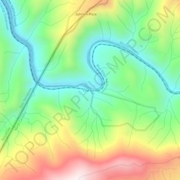
Name: Lost Cove topographic map, elevation, terrain.

Location: Lost Cove, Yancey County, North Carolina, United States (36.05094 -82.42236 36.09094 -82.38236)

Average elevation: 852 m

Minimum elevation: 520 m

Maximum elevation: 1,390 m

Gear up for your next adventure:

🪑Insulated Seat Pad - Protect your seat from cold rocks and wet logs
🧰Emergency Multi-Tool - Compact multi-tool for outdoor survival
👟Trail Running Shoes - Agile footwear for fast-paced topographic exploration
🔭Compact Monocular - One-handed bird watching and trail spotting
🧦Hiking Liner Socks - Thin base layer to prevent friction and blisters

As an Amazon Associate, this site earns from qualifying purchases at no extra cost to you.