Geolocate

Rozo topographic map

Click on the map to display elevation.

About this map

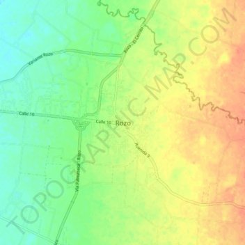
Name: Rozo topographic map, elevation, terrain.

Location: Rozo, Palmira, Sur, Valle del Cauca, RAP Pacífico, Colombia (3.57477 -76.42597 3.65477 -76.34597)

Average elevation: 964 m

Minimum elevation: 944 m

Maximum elevation: 984 m

Other topographic maps

Click on a map to view its topography, its elevation and its terrain.

Río Nima

Colombia > Valle del Cauca > Palmira

Average elevation: 1,300 m

Gear up for your next adventure:

🥘Camping Cookware Set - Compact nesting pots and pans for trail cooking
🔋Solar Power Bank - Keep your GPS and devices charged during long outdoor trips
Camping Groundsheet - Protect your tent from moisture and dirt
🚲Bike Repair Kit - Essential tools for on-trail mechanical issues
🧼Travel Hand Sanitizer - Keep hands clean when water is scarce

As an Amazon Associate, this site earns from qualifying purchases at no extra cost to you.