Geolocate

Garrison topographic map

Click on the map to display elevation.

About this map

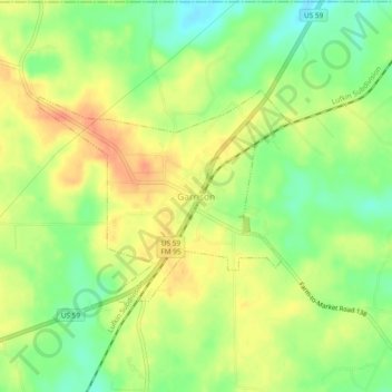
Name: Garrison topographic map, elevation, terrain.

Location: Garrison, Nacogdoches County, Texas, 75946, United States (31.80434 -94.51104 31.84434 -94.47104)

Average elevation: 113 m

Minimum elevation: 89 m

Maximum elevation: 133 m

Gear up for your next adventure:

🚲Handlebar Phone Mount - View topographic-map.com live while cycling
🔭Compact Binoculars - Lightweight optics for scouting trails and wildlife
🧢Outdoor Visor - Breathable visor for sunny hikes
🥾Hiking Boots - Sturdy boots providing ankle support and traction on rugged trails
🚑Survival Whistle - Signal for help across long distances in mountains

As an Amazon Associate, this site earns from qualifying purchases at no extra cost to you.