Geolocate

Tamalameque topographic map

Click on the map to display elevation.

About this map

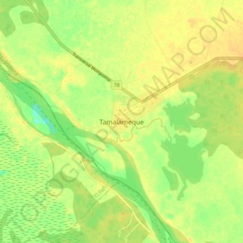
Name: Tamalameque topographic map, elevation, terrain.

Location: Tamalameque, Cesar, Colombia (8.81683 -73.85575 8.89683 -73.77575)

Average elevation: 30 m

Minimum elevation: 15 m

Maximum elevation: 38 m

Gear up for your next adventure:

🛏️Camping Sleeping Mat - Comfortable mats for sleeping outdoors
🎒Backpack Rain Cover - External shield to keep your entire pack dry
🥾Mountain Hiking Boots - High-traction boots for rocky terrain
💡Compact LED Flashlight - Powerful and portable flashlight for outdoor use
🧢Sun Protection Cap - Breathable cap to protect from sun exposure

As an Amazon Associate, this site earns from qualifying purchases at no extra cost to you.