Geolocate

Peña Redonda topographic map

Click on the map to display elevation.

About this map

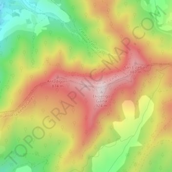
Name: Peña Redonda topographic map, elevation, terrain.

Location: Peña Redonda, Puente la Reina, Izarbeibar, Navarra, España (42.74214 -1.81123 42.74224 -1.81113)

Average elevation: 676 m

Minimum elevation: 420 m

Maximum elevation: 908 m

Gear up for your next adventure:

🥾Trail Running Shoes - Lightweight and durable shoes for trail running
🔦LED Flashlight - Powerful and long-lasting flashlight for camping and emergencies
🏃Hydration Running Vest - Carry water and maps close to your body for speed
🏕️Camping Hammock - Integrated protection for sleeping between trees
🩹Compact First Aid Kit - Pre-packed essentials for common trail injuries

As an Amazon Associate, this site earns from qualifying purchases at no extra cost to you.