Geolocate

Savah topographic map

Click on the map to display elevation.

About this map

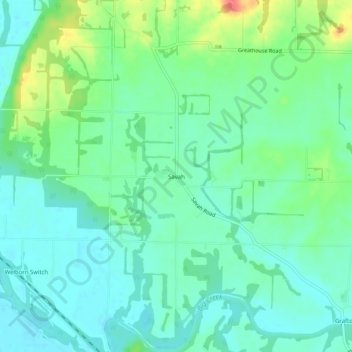
Name: Savah topographic map, elevation, terrain.

Location: Savah, Posey County, Indiana, United States (37.99782 -87.99864 38.03782 -87.95864)

Average elevation: 122 m

Minimum elevation: 105 m

Maximum elevation: 164 m

Gear up for your next adventure:

🏕️Camping Hammock - Integrated protection for sleeping between trees
🕶️Polarized Sunglasses - Reduces glare from snow and water at high elevations
🧦Crew Hiking Socks - Comfortable socks for long-distance hikes
🥾All-Terrain Hiking Boots - Versatile boots for varied hiking conditions
🔭Compact Monocular - One-handed bird watching and trail spotting

As an Amazon Associate, this site earns from qualifying purchases at no extra cost to you.