Geolocate

Vallada topographic map

Click on the map to display elevation.

About this map

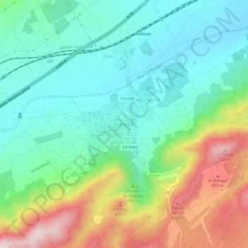
Name: Vallada topographic map, elevation, terrain.

Location: Vallada, La Costera, Valencia, Comunidad Valenciana, España (38.87594 -0.70910 38.91594 -0.66910)

Average elevation: 388 m

Minimum elevation: 227 m

Maximum elevation: 733 m

Gear up for your next adventure:

🛰️Satellite Messenger - Emergency communication for areas with no cell service
👟Sport Hiking Sandals - Breathable footwear for water crossings and camp rest
🥘Camping Cookware Set - Compact nesting pots and pans for trail cooking
🦟Insect Repellent - Keep mosquitoes and black flies away in wooded areas
🥾All-Terrain Hiking Boots - Versatile boots for varied hiking conditions

As an Amazon Associate, this site earns from qualifying purchases at no extra cost to you.