Geolocate

Isla Verde topographic map

Click on the map to display elevation.

About this map

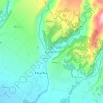
Name: Isla Verde topographic map, elevation, terrain.

Location: Isla Verde, Ormoc, Leyte, Eastern Visayas, 6541, Philippines (10.96990 124.64155 11.00990 124.68155)

Average elevation: 84 m

Minimum elevation: 3 m

Maximum elevation: 299 m

Other topographic maps

Click on a map to view its topography, its elevation and its terrain.

Binahaan River

Philippines > Leyte > Ormoc

Average elevation: 546 m

Binahaan River

Philippines > Leyte > Ormoc

Average elevation: 495 m

Ormoc City Proper

Philippines > Leyte > Ormoc

Average elevation: 18 m

Gear up for your next adventure:

🔋Solar Power Bank - Keep your GPS and devices charged during long outdoor trips
🧢Hiking Sun Hat - Wide-brimmed protection for exposed mountain ridges
🥤Collapsible Travel Cup - Saves space and weight in your mess kit
🥾Light Hiking Boots - Lightweight and comfortable boots for day hikes
💧Hydration Pack - Hands-free hydration system for long hikes

As an Amazon Associate, this site earns from qualifying purchases at no extra cost to you.