
Thank you for supporting this site ❤️
Make a donation
Make a donation
Gear up for your next adventure:
As an Amazon Associate, this site earns from qualifying purchases at no extra cost to you.
Fünfeichen topographic map
Click on the map to display elevation.
Thank you for supporting this site ❤️
Make a donation
Make a donation
Gear up for your next adventure:
As an Amazon Associate, this site earns from qualifying purchases at no extra cost to you.
About this map
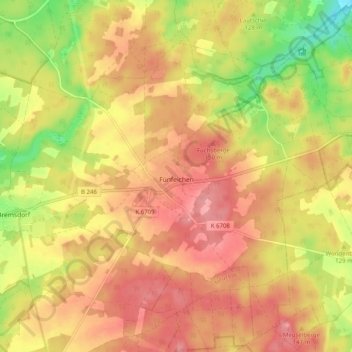
Name: Fünfeichen topographic map, elevation, terrain.
Location: Fünfeichen, Schlaubetal, Oder-Spree, Brandenburg, Deutschland (52.11657 14.49833 52.17375 14.59873)
Average elevation: 121 m
Minimum elevation: 60 m
Maximum elevation: 160 m
Thank you for supporting this site ❤️
Make a donation
Make a donation
Gear up for your next adventure:
As an Amazon Associate, this site earns from qualifying purchases at no extra cost to you.
Other topographic maps
Click on a map to view its topography, its elevation and its terrain.
Großer Treppelsee
Deutschland > Brandenburg > Oder-Spree > Schlaubetal > Bremsdorf
Average elevation: 79 m