Geolocate

Bagrakote topographic map

Click on the map to display elevation.

About this map

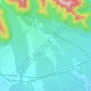
Name: Bagrakote topographic map, elevation, terrain.

Location: Bagrakote, Mal, Jalpaiguri District, West Bengal, India (26.86125 88.55674 26.90125 88.59674)

Average elevation: 212 m

Minimum elevation: 149 m

Maximum elevation: 462 m

Gear up for your next adventure:

Tent Footprint - Protect tent floor and increase durability
🥾Mountaineering Boots - Supportive boots for climbing and high-altitude hiking
🧭GPS Handheld Device - Reliable GPS navigation for outdoor adventures
💡Portable Camping Lamp - Rechargeable lamp for campsite lighting
🧥Softshell Hiking Jacket - The perfect balance of wind protection and breathability

As an Amazon Associate, this site earns from qualifying purchases at no extra cost to you.