
Make a donation
Gear up for your next adventure:
As an Amazon Associate, this site earns from qualifying purchases at no extra cost to you.
Wetzlar topographic map
Click on the map to display elevation.
Make a donation
Gear up for your next adventure:
As an Amazon Associate, this site earns from qualifying purchases at no extra cost to you.
Wetzlar
Wetzlars wirtschaftliche Bedeutung beruht auf seiner optischen, feinmechanischen, elektrotechnischen und stahlverarbeitenden Industrie. Wetzlar ist als Sportstadt mit bedeutenden Sportlern, Sportveranstaltungen und -vereinen bekannt. Es spielen einige Mannschaften in den jeweiligen Bundesligen. Zur sportlichen Förderung sind mehrere überregionale Leistungszentren und Stützpunkte angesiedelt. Das Stadtgebiet liegt in Höhe des Zusammenflusses von Dill und Lahn.
Make a donation
Gear up for your next adventure:
As an Amazon Associate, this site earns from qualifying purchases at no extra cost to you.
About this map
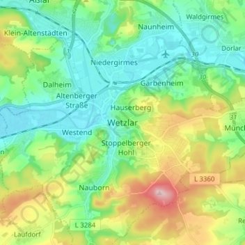
Name: Wetzlar topographic map, elevation, terrain.
Location: Wetzlar, Lahn-Dill-Kreis, Hessen, 35578, Deutschland (50.51253 8.46744 50.59253 8.54744)
Average elevation: 217 m
Minimum elevation: 143 m
Maximum elevation: 388 m
Make a donation
Gear up for your next adventure:
As an Amazon Associate, this site earns from qualifying purchases at no extra cost to you.