
Make a donation
Gear up for your next adventure:
As an Amazon Associate, this site earns from qualifying purchases at no extra cost to you.
Espelkamp topographic map
Click on the map to display elevation.
Make a donation
Gear up for your next adventure:
As an Amazon Associate, this site earns from qualifying purchases at no extra cost to you.
Espelkamp
Das Stadtgebiet liegt rund 15 km nördlich des Wiehengebirges und vollständig in der Norddeutschen Tiefebene. Das Gebiet ist daher weitgehend eben; markante Berge gibt es nicht. Der nur knapp seine Umgebung überragende Hügel in Fabbenstedt ist mit knapp 70 Metern der höchste Punkt der Stadt. Ansonsten liegt das Stadtgebiet durchschnittlich auf einer Höhe von rund 45 Metern, einzelne Gebiete im Nordwesten der Stadt an der Großen Aue auch nur noch knapp über 40 Meter. Espelkamp liegt weiterhin im Altmoränengebiet Rahden-Diepenauer Geest – einer naturräumlichen Untereinheit der Dümmer-Geestniederung.
Make a donation
Gear up for your next adventure:
As an Amazon Associate, this site earns from qualifying purchases at no extra cost to you.
About this map
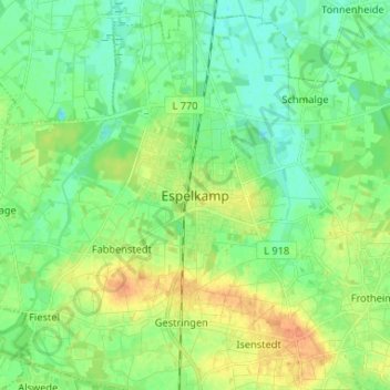
Name: Espelkamp topographic map, elevation, terrain.
Average elevation: 51 m
Minimum elevation: 37 m
Maximum elevation: 74 m
Make a donation
Gear up for your next adventure:
As an Amazon Associate, this site earns from qualifying purchases at no extra cost to you.