Geolocate

Lobbot topographic map

Click on the map to display elevation.

About this map

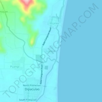
Name: Lobbot topographic map, elevation, terrain.

Location: Lobbot, Dipaculao, Aurora, Central Luzon, 3203, Philippines (15.84332 121.52443 15.88332 121.56443)

Average elevation: 17 m

Minimum elevation: -1 m

Maximum elevation: 212 m

Gear up for your next adventure:

💧Filtered Water Bottle - Safe drinking water on the go
🥾Waterproof Hiking Boots - Boots keeping your feet dry in wet conditions
🧭GPS Tracker - Track your location in remote areas safely
🧦Crew Hiking Socks - Comfortable socks for long-distance hikes
🥾Waterproof Hiking Shoes - Durable shoes for wet and rugged trails

As an Amazon Associate, this site earns from qualifying purchases at no extra cost to you.