Geolocate

El Conillo topographic map

Click on the map to display elevation.

About this map

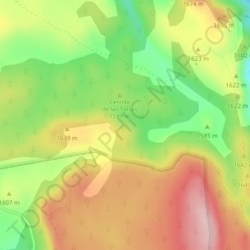
Name: El Conillo topographic map, elevation, terrain.

Location: El Conillo, Cuenca, Castilla-La Mancha, España (40.47179 -1.91206 40.49179 -1.89206)

Average elevation: 1,609 m

Minimum elevation: 1,490 m

Maximum elevation: 1,721 m

Other topographic maps

Click on a map to view its topography, its elevation and its terrain.

Rio Júcar

España > Castilla-La Mancha > Cuenca

Average elevation: 955 m

Embalse de La Toba

España > Castilla-La Mancha > Cuenca

Average elevation: 1,261 m

Gear up for your next adventure:

🧥Waterproof Hiking Jacket - Protect yourself from rain and wind while hiking
🔦LED Flashlight - Powerful and long-lasting flashlight for camping and emergencies
🧤Insulated Winter Gloves - Heavy-duty protection for sub-zero Canadian adventures
🔥Camping Stove - Portable stoves to cook outdoors with ease
🧴Insect Repellent - Protect yourself from bugs during outdoor adventures

As an Amazon Associate, this site earns from qualifying purchases at no extra cost to you.