Geolocate

Estes Park topographic map

Click on the map to display elevation.

About this map

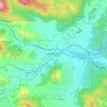
Name: Estes Park topographic map, elevation, terrain.

Location: Estes Park, Larimer County, Colorado, 80517, United States (40.33719 -105.56322 40.41719 -105.48322)

Average elevation: 2,461 m

Minimum elevation: 2,247 m

Maximum elevation: 3,186 m

Gear up for your next adventure:

🛌Insulated Sleeping Pad - Critical thermal barrier between you and the cold ground
🚲MTB Frame Bag - Carry tools and maps directly on your bicycle frame
👖Convertible Hiking Pants - Zip-off legs to adapt to changing weather conditions
🧥Waterproof Pants - Keep dry during rainy hiking conditions
🧥Softshell Jacket - Windproof and breathable jacket for hiking

As an Amazon Associate, this site earns from qualifying purchases at no extra cost to you.