
Jarrell topographic map
Click on the map to display elevation.
About this map
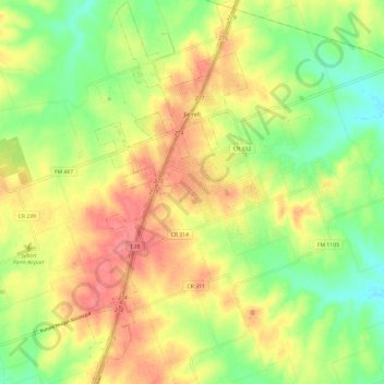
Name: Jarrell topographic map, elevation, terrain.
Location: Jarrell, Williamson County, Texas, United States (30.75265 -97.63773 30.85521 -97.58711)
Average elevation: 252 m
Minimum elevation: 217 m
Maximum elevation: 286 m
Other topographic maps
Click on a map to view its topography, its elevation and its terrain.
Georgetown
United States > Texas > Williamson County > Georgetown
The city is located on the northeastern edge of Texas Hill Country. Portions of Georgetown are located on either side of the Balcones Escarpment, a fault line in which the areas roughly east of IH-35 are flat and characterized by having black, fertile soils of the Blackland Prairie, and the west side of the…
Average elevation: 228 m
Soil Conservation Service Site 12 Dam
United States > Texas > Williamson County > Type
Average elevation: 173 m
Soil Conservation Service Site 12 Dam
United States > Texas > Williamson County > Type
Average elevation: 173 m
Soil Conservation Service Site 12 Dam
United States > Texas > Williamson County > Type
Average elevation: 173 m