Geolocate

Sarno topographic map

Click on the map to display elevation.

About this map

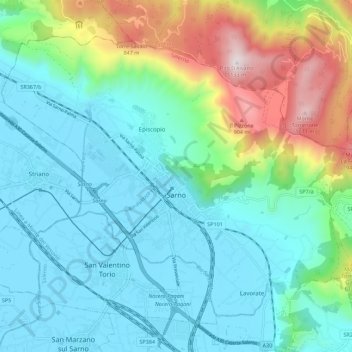
Name: Sarno topographic map, elevation, terrain.

Location: Sarno, Salerno, Campania, 84087, Italy (40.78185 14.56471 40.84875 14.67555)

Average elevation: 270 m

Minimum elevation: 12 m

Maximum elevation: 1,117 m

Other topographic maps

Click on a map to view its topography, its elevation and its terrain.

Marina di Vietri

Italy > Campania > Salerno > Vietri sul Mare

Average elevation: 141 m

Pogerola

Italy > Campania > Salerno

Average elevation: 363 m

Civitella

Italy > Campania > Salerno > Moio della Civitella

Average elevation: 614 m

Monte Cervati

Italy > Campania > Salerno > Sanza

Average elevation: 1,622 m

Catona

Italy > Campania > Salerno

Average elevation: 428 m

Iaconti

Italy > Campania > Salerno > Vietri sul Mare

Average elevation: 285 m

Erchie

Italy > Campania > Salerno > Maiori

Average elevation: 131 m

Ariano

Italy > Campania > Salerno

Average elevation: 281 m

Bosco

Italy > Campania > Salerno

Average elevation: 388 m

San Severino

Italy > Campania > Salerno > Centola

Average elevation: 273 m

Montepertuso

Italy > Campania > Salerno > Arienzo

Average elevation: 455 m

Gear up for your next adventure:

🧦Hiking Liner Socks - Thin base layer to prevent friction and blisters
🔪Outdoor Multitool - Versatile tool for repairs and food prep in the wild
🩹Moleskin Blister Pads - Direct protection for painful foot pressure points
🛁Quick-Dry Microfiber Towel - Space-saving towel that dries rapidly on the move
🛌Down Sleeping Bag - Superior warmth-to-weight ratio for cold nights

As an Amazon Associate, this site earns from qualifying purchases at no extra cost to you.