Geolocate

Marietta topographic map

Click on the map to display elevation.

About this map

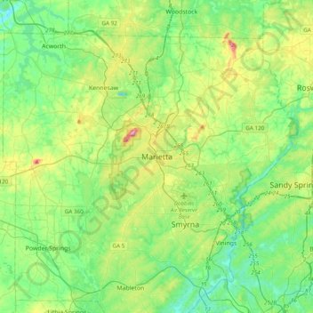
Name: Marietta topographic map, elevation, terrain.

Location: Marietta, Cobb County, Georgia, 30090, United States (33.79285 -84.70961 34.11285 -84.38961)

Average elevation: 302 m

Minimum elevation: 216 m

Maximum elevation: 529 m

Gear up for your next adventure:

🥘Camping Cookware Set - Compact nesting pots and pans for trail cooking
🧥Insulated Jacket - Keep warm in cold outdoor conditions
🗺️Topographic Maps - Detailed maps to explore trails, mountains, and wilderness areas
🔋Solar Power Bank - Keep your GPS and devices charged during long outdoor trips
🥾Hiking Shoes - Durable and comfortable shoes for trail hiking

As an Amazon Associate, this site earns from qualifying purchases at no extra cost to you.