Geolocate

Bello topographic map

Click on the map to display elevation.

Bello

Topographically the urban part of the city is a tilted plane that descends from 1600 to 1400 meters above sea level. Bello is in the northern part of the valley and the mountains surrounding the city exceed 2,500 meters.

Wikipedia (CC-BY-SA 3.0)

About this map

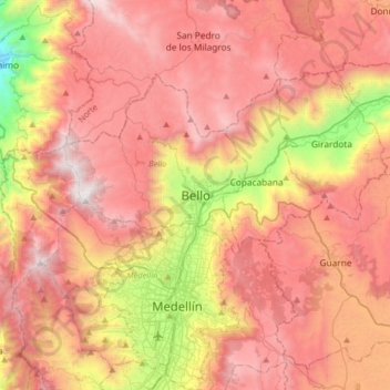
Name: Bello topographic map, elevation, terrain.

Location: Bello, Valle de Aburrá, Antioquia, RAP del Agua y la Montaña, 051053, Colombia (6.17500 -75.71827 6.49500 -75.39827)

Average elevation: 2,145 m

Minimum elevation: 773 m

Maximum elevation: 3,129 m

Gear up for your next adventure:

🥫Freeze-Dried Meals - Lightweight, high-calorie nutrition for multi-day treks
🪑Insulated Seat Pad - Protect your seat from cold rocks and wet logs
Camping Groundsheet - Protect your tent from moisture and dirt
Bushcraft Tarp - Versatile emergency shelter or gear protection
🥾Hiking Leggings - Comfortable leggings for outdoor activities

As an Amazon Associate, this site earns from qualifying purchases at no extra cost to you.