Geolocate

Distrito II topographic map

Click on the map to display elevation.

About this map

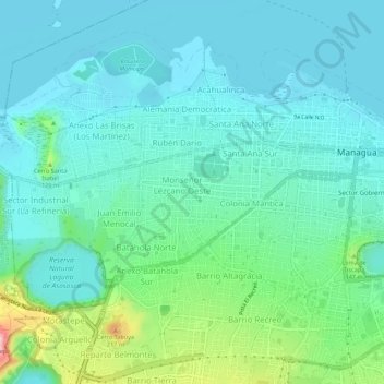
Name: Distrito II topographic map, elevation, terrain.

Location: Distrito II, Managua, 12000, Nicaragua (12.12632 -86.32815 12.17117 -86.27334)

Average elevation: 82 m

Minimum elevation: 34 m

Maximum elevation: 268 m

Other topographic maps

Click on a map to view its topography, its elevation and its terrain.

Laguna de Tiscapa

Nicaragua > Managua > Managua

Average elevation: 90 m

Gear up for your next adventure:

🔭Compact Monocular - One-handed bird watching and trail spotting
🥾Durable Hiking Shoes - Long-lasting shoes for frequent hiking
🧭GPS Tracker - Track your location in remote areas safely
🪑Insulated Seat Pad - Protect your seat from cold rocks and wet logs
🧥Softshell Jacket - Windproof and breathable jacket for hiking

As an Amazon Associate, this site earns from qualifying purchases at no extra cost to you.