
Thank you for supporting this site ❤️
Make a donation
Make a donation
Gear up for your next adventure:
As an Amazon Associate, this site earns from qualifying purchases at no extra cost to you.
Rüggeberg topographic map
Click on the map to display elevation.
Thank you for supporting this site ❤️
Make a donation
Make a donation
Gear up for your next adventure:
As an Amazon Associate, this site earns from qualifying purchases at no extra cost to you.
Rüggeberg
Der Ort liegt im südlichen Ennepe-Ruhr-Kreis, direkt an der Grenze des Sauerlandes zum Bergischen Land auf einem Höhenrücken zwischen den Flüssen Ennepe und Heilenbecke.
Thank you for supporting this site ❤️
Make a donation
Make a donation
Gear up for your next adventure:
As an Amazon Associate, this site earns from qualifying purchases at no extra cost to you.
About this map
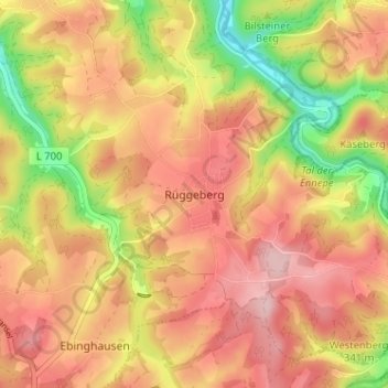
Name: Rüggeberg topographic map, elevation, terrain.
Average elevation: 319 m
Minimum elevation: 206 m
Maximum elevation: 394 m
Thank you for supporting this site ❤️
Make a donation
Make a donation
Gear up for your next adventure:
As an Amazon Associate, this site earns from qualifying purchases at no extra cost to you.