Geolocate

Zala topographic map

Click on the map to display elevation.

About this map

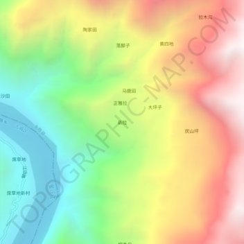
Name: Zala topographic map, elevation, terrain.

Location: Zala, Yongsheng County, Lijiang City, Yunnan, China (26.59678 100.42057 26.63678 100.46057)

Average elevation: 2,048 m

Minimum elevation: 1,234 m

Maximum elevation: 2,993 m

Gear up for your next adventure:

🎒Backpack Rain Cover - External shield to keep your entire pack dry
👟Sport Hiking Sandals - Breathable footwear for water crossings and camp rest
🦶Anti-Blister Balm - Prevents friction and hotspots during long ascents
🔋Emergency Crank Radio - Weather alerts and power without needing batteries
🧳Compression Sacks - Maximize space in your backpack by shrinking gear

As an Amazon Associate, this site earns from qualifying purchases at no extra cost to you.