Geolocate

Zhangjiang topographic map

Click on the map to display elevation.

About this map

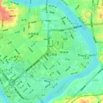
Name: Zhangjiang topographic map, elevation, terrain.

Location: Zhangjiang, Zhanggong District, Ganzhou, Jiangxi, China (25.80139 114.91656 25.84501 114.95314)

Average elevation: 109 m

Minimum elevation: 91 m

Maximum elevation: 144 m

Gear up for your next adventure:

🎒Fully Waterproof Backpack - Total protection for photography gear and electronics
🐕Hiking Dog Pack - Let your canine companion carry their own water and food
🧴Insect Repellent - Protect yourself from bugs during outdoor adventures
💧Hydration Bladder - Hands-free hydration solution for long treks
🧢Hiking Hat - Sun-protective and breathable hats for long treks

As an Amazon Associate, this site earns from qualifying purchases at no extra cost to you.