Geolocate

Santa Marta topographic map

Click on the map to display elevation.

About this map

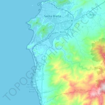
Name: Santa Marta topographic map, elevation, terrain.

Location: Santa Marta, Magdalena, RAP Caribe, Colombia (11.07884 -74.24180 11.25925 -74.13999)

Average elevation: 214 m

Minimum elevation: -1 m

Maximum elevation: 1,460 m

Gear up for your next adventure:

🧳Compression Sacks - Maximize space in your backpack by shrinking gear
🥾Hiking Shoes - Durable and comfortable shoes for trail hiking
🧰Multitool Knife - Compact and versatile tool for outdoor use
💧Reusable Water Bottle - Durable water bottles for hydration on trails
💧Filtered Water Bottle - Safe drinking water on the go

As an Amazon Associate, this site earns from qualifying purchases at no extra cost to you.