Geolocate

Tiñana topographic map

Click on the map to display elevation.

About this map

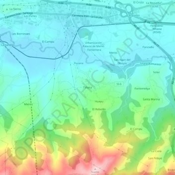
Name: Tiñana topographic map, elevation, terrain.

Location: Tiñana, Siero, Asturias, 33199, España (43.34682 -5.77170 43.38682 -5.73170)

Average elevation: 246 m

Minimum elevation: 166 m

Maximum elevation: 477 m

Other topographic maps

Click on a map to view its topography, its elevation and its terrain.

San Juan Arenas

España > Asturias > Siero

Average elevation: 334 m

Santiago Arenas

España > Asturias > Siero

Average elevation: 400 m

Collado

España > Asturias > Siero

Average elevation: 288 m

Gear up for your next adventure:

🍽️Titanium Camping Spork - Ultralight and indestructible eating utensil
🔋Lithium AA Batteries - Long-lasting power that performs in extreme cold
🔦LED Flashlight - Powerful and long-lasting flashlight for camping and emergencies
🔭Outdoor Binoculars - Lightweight binoculars for birdwatching and hiking
🔥Camping Stove - Portable stoves to cook outdoors with ease

As an Amazon Associate, this site earns from qualifying purchases at no extra cost to you.