Geolocate

Durlach topographic map

Click on the map to display elevation.

About this map

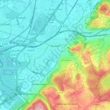
Name: Durlach topographic map, elevation, terrain.

Location: Durlach, Karlsruhe, Baden-Württemberg, 76227, Germany (48.96428 8.41474 49.02400 8.51045)

Average elevation: 158 m

Minimum elevation: 107 m

Maximum elevation: 295 m

Other topographic maps

Click on a map to view its topography, its elevation and its terrain.

Untere Hub

Germany > Baden-Württemberg > Karlsruhe

Average elevation: 121 m

Erlachsee

Germany > Baden-Württemberg > Karlsruhe > Durlach

Average elevation: 117 m

Gear up for your next adventure:

🛶Kayak Dry Bag - Waterproof storage for kayaking adventures
🎒Backpack Rain Cover - External shield to keep your entire pack dry
🥾Mountain Hiking Shoes - Shoes with superior grip for mountainous terrain
🧢Hiking Hat - Sun-protective and breathable hats for long treks
🎒Fully Waterproof Backpack - Total protection for photography gear and electronics

As an Amazon Associate, this site earns from qualifying purchases at no extra cost to you.