
Hoher Dachstein topographic map
Interactive map
Click on the map to display elevation.
About this map
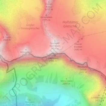
Name: Hoher Dachstein topographic map, elevation, terrain.
Average elevation: 2,342 m
Minimum elevation: 1,579 m
Maximum elevation: 2,903 m
Le Hoher Dachstein ou Haut Dachstein est un sommet des Alpes, à 2 995 m d'altitude, point culminant du massif du Dachstein, en Autriche (limite entre la Haute-Autriche et la Styrie).