
Make a donation
Gear up for your next adventure:
As an Amazon Associate, this site earns from qualifying purchases at no extra cost to you.
Stetternich topographic map
Click on the map to display elevation.
Make a donation
Gear up for your next adventure:
As an Amazon Associate, this site earns from qualifying purchases at no extra cost to you.
Stetternich
Stetternich liegt in der Jülich-Zülpicher Börde westlich der Sophienhöhe. Im Norden und Osten wird der Ort vom Lindenberger Wald umgeben. Im Süden und Westen verlaufen der Mühlengraben und der Ellebach. Etwa 1 km südlich von Stetternich im Selgenbusch liegt das Forschungszentrum Jülich. Nachbarorte sind Hambach im Süden, im Nordwesten Jülich und Lich-Steinstraß sowie im Norden Welldorf. Direkt am nördlichen Ortsrand verläuft die Bundesstraße 55, die alte römische Via Belgica.
Make a donation
Gear up for your next adventure:
As an Amazon Associate, this site earns from qualifying purchases at no extra cost to you.
About this map
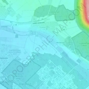
Name: Stetternich topographic map, elevation, terrain.
Average elevation: 100 m
Minimum elevation: 83 m
Maximum elevation: 238 m
Make a donation
Gear up for your next adventure:
As an Amazon Associate, this site earns from qualifying purchases at no extra cost to you.
Other topographic maps
Click on a map to view its topography, its elevation and its terrain.
Forsthaus Stetternich
Deutschland > Nordrhein-Westfalen > Kreis Düren > Jülich > Lich-Steinstraß
Average elevation: 93 m
Make a donation
Gear up for your next adventure:
As an Amazon Associate, this site earns from qualifying purchases at no extra cost to you.
Brückenkopfpark
Deutschland > Nordrhein-Westfalen > Kreis Düren > Jülich > Koslar
Der Brückenkopf ist als Kronwerk ausgelegt und weist eine Breite von etwa 800 Metern, eine Tiefe von etwa 300 Metern und eine Höhe von etwa zehn Metern auf. Er besteht im Wesentlichen aus mit Mauern abgestütztem Erdreich. Auf dem Wall befinden sich tonnengewölbte Hohltraversen zur Aufstellung von…
Average elevation: 83 m