
Dungri topographic map
Click on the map to display elevation.
About this map
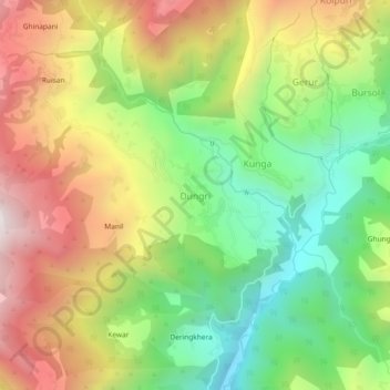
Name: Dungri topographic map, elevation, terrain.
Location: Dungri, Tharali, Chamoli District, Uttarakhand, 246481, India (30.10743 79.48537 30.14743 79.52537)
Average elevation: 1,992 m
Minimum elevation: 1,489 m
Maximum elevation: 2,601 m
Other topographic maps
Click on a map to view its topography, its elevation and its terrain.
Pindar
India > Uttarakhand > Tharali
The Pindar River is a river located in Uttarakhand, India. The Pindar originates from Pindari Glacier which is located in Bageshwar district of Kumaon region in Uttarakhand. The source of this river, the Pindar glacier is located at an altitude of 3,820 m (12,530 ft). Pindar glacier has relatively easier…
Average elevation: 2,533 m