Geolocate

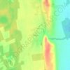
Balatonlelle topographic map

Click on the map to display elevation.

About this map

Name: Balatonlelle topographic map, elevation, terrain.

Location: Balatonlelle, Fonyódi járás, Somogy, Transdanubia, 8638, Hungary (46.73489 17.66839 46.82869 17.78963)

Average elevation: 118 m

Minimum elevation: 99 m

Maximum elevation: 280 m

Other topographic maps

Click on a map to view its topography, its elevation and its terrain.
Kaposvár

Hungary > Somogy > Kaposvár

Average elevation: 173 m

Alsósegesd

Hungary > Somogy > Segesd

Average elevation: 161 m

Gear up for your next adventure:

🥾Trail Hiking Socks - Comfortable socks to prevent blisters and fatigue
🔭Outdoor Binoculars - Lightweight binoculars for birdwatching and hiking
🥽Outdoor Goggles - Protective eyewear for outdoor activities
🧤Insulated Winter Gloves - Heavy-duty protection for sub-zero Canadian adventures
👟Leg Gaiters - Keep debris, mud, and snow out of your boots

As an Amazon Associate, this site earns from qualifying purchases at no extra cost to you.