
Make a donation
Gear up for your next adventure:
As an Amazon Associate, this site earns from qualifying purchases at no extra cost to you.
Tisbury topographic map
Click on the map to display elevation.
Make a donation
Gear up for your next adventure:
As an Amazon Associate, this site earns from qualifying purchases at no extra cost to you.
Tisbury
Measuring from the western shore of Tisbury to Nobska Point at Woods Hole (town of Falmouth), the town is 3.3 miles (5.3 km) from the mainland (Cape Cod), the closest point on the Vineyard. Most of central Tisbury is low-lying and near sea level, with elevations rising to 150 feet (46 m) in places. West Chop is the northernmost point on the Vineyard, tipped by the West Chop Light. The town is also home to Lake Tashmoo, just south of the tip of West Chop.
Make a donation
Gear up for your next adventure:
As an Amazon Associate, this site earns from qualifying purchases at no extra cost to you.
About this map
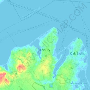
Name: Tisbury topographic map, elevation, terrain.
Location: Tisbury, Dukes County, Massachusetts, United States (41.41363 -70.67388 41.51181 -70.56482)
Average elevation: 8 m
Minimum elevation: -7 m
Maximum elevation: 70 m
Make a donation
Gear up for your next adventure:
As an Amazon Associate, this site earns from qualifying purchases at no extra cost to you.
Other topographic maps
Click on a map to view its topography, its elevation and its terrain.
Southern Woodlands Reservation
United States > Massachusetts > Dukes County > Oak Bluffs
Average elevation: 17 m
Make a donation
Gear up for your next adventure:
As an Amazon Associate, this site earns from qualifying purchases at no extra cost to you.
North Tisbury
United States > Massachusetts > Dukes County > West Tisbury > North Tisbury
Average elevation: 24 m