
Coldstream topographic map
Interactive map
Click on the map to display elevation.
About this map
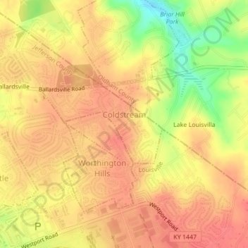
Name: Coldstream topographic map, elevation, terrain.
Location: Coldstream, Jefferson County, Kentucky, United States (38.30945 -85.53546 38.31795 -85.51861)
Average elevation: 219 m
Minimum elevation: 177 m
Maximum elevation: 238 m
Other topographic maps
Click on a map to view its topography, its elevation and its terrain.
Louisville
United States > Kentucky > Jefferson County
Louisville, Jefferson County, Kentucky, United States
Average elevation: 188 m
Moorland
United States > Kentucky > Jefferson County > Lyndon
Moorland, Lyndon, Jefferson County, Kentucky, 40242, United States
Average elevation: 193 m
Prospect
United States > Kentucky > Jefferson County
Prospect, Jefferson County, Kentucky, United States
Average elevation: 166 m
Thornhill
United States > Kentucky > Jefferson County
Thornhill, Jefferson County, Kentucky, United States
Average elevation: 180 m