Geolocate

Critz topographic map

Click on the map to display elevation.

About this map

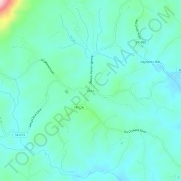
Name: Critz topographic map, elevation, terrain.

Location: Critz, Patrick County, Virginia, 24082, United States (36.61014 -80.16477 36.65014 -80.12477)

Average elevation: 336 m

Minimum elevation: 285 m

Maximum elevation: 573 m

Other topographic maps

Click on a map to view its topography, its elevation and its terrain.

Stuart

United States > Virginia > Patrick County

Average elevation: 411 m

Stuart

United States > Virginia > Patrick County

Average elevation: 411 m

Stuart

United States > Virginia > Patrick County

Average elevation: 416 m

Gear up for your next adventure:

Lightweight Backpacking Tent - Compact tent for efficient hiking trips
🧥Fleece Jacket - Warm and lightweight jacket for layering
🧤Insulated Winter Gloves - Heavy-duty protection for sub-zero Canadian adventures
Camping Coffee Maker - Brew fresh coffee anywhere on the topographic map
🛶Kayak Accessories - Essential gear for safe and fun kayaking adventures

As an Amazon Associate, this site earns from qualifying purchases at no extra cost to you.