Geolocate

Death Valley Playa topographic map

Click on the map to display elevation.

About this map

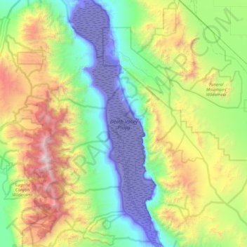
Name: Death Valley Playa topographic map, elevation, terrain.

Location: Death Valley Playa, Inyo County, California, United States (35.93852 -117.00402 36.58081 -116.71460)

Average elevation: 881 m

Minimum elevation: -83 m

Maximum elevation: 3,336 m

Other topographic maps

Click on a map to view its topography, its elevation and its terrain.

Furnace Creek

United States > California > Inyo County

Average elevation: -27 m

Margaret Lake

United States > California > Inyo County

Average elevation: 3,467 m

Gear up for your next adventure:

🛶Waterproof Dry Bags - Keep electronics and clothes dry during river crossings
🧦Outdoor Socks - Durable socks designed for hiking and outdoor sports
🧥Packable Rain Jacket - Breathable waterproof layer for unpredictable weather
🪑Ultralight Camping Stool - Compact seating for rest stops during long hikes
🥾Trail Hiking Boots - Supportive boots for rough trails

As an Amazon Associate, this site earns from qualifying purchases at no extra cost to you.