Geolocate

Mt. Tate topographic map

Click on the map to display elevation.

Mt. Tate

The mountain is primarily composed of granite and gneiss. However, located along the ridge and plateau, about 2 km (1.2 mi) west of the summit, there is a small andesite-dacite stratovolcano. This volcano has an elevation of 2,621 m (8,599 ft) and has minor eruptions, the latest occurring in 1961.

Wikipedia (CC-BY-SA 3.0)

About this map

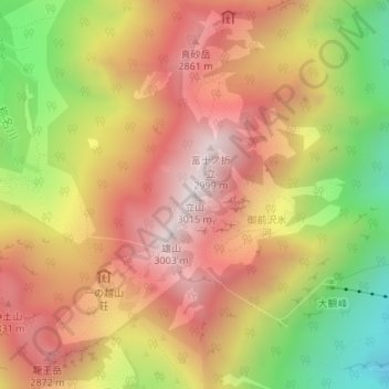
Name: Mt. Tate topographic map, elevation, terrain.

Location: Mt. Tate, Tateyama, Nakaniikawa County, Toyama Prefecture, 930-1406, Japan (36.57595 137.61986 36.57605 137.61996)

Average elevation: 2,556 m

Minimum elevation: 1,959 m

Maximum elevation: 3,000 m

Other topographic maps

Click on a map to view its topography, its elevation and its terrain.

Gozenzawa Glacier

Japan > Nakaniikawa County > Tateyama

Average elevation: 2,449 m

Gear up for your next adventure:

🧼Travel Hand Sanitizer - Keep hands clean when water is scarce
🔨Vehicle Emergency Tool - Safety tool for remote road trips to trailheads
🥾Mountaineering Boots - Supportive boots for climbing and high-altitude hiking
🧰Emergency Multi-Tool - Compact multi-tool for outdoor survival
🧣Evaporative Cooling Towel - Beat the heat during intense summer climbs

As an Amazon Associate, this site earns from qualifying purchases at no extra cost to you.