
Make a donation
Gear up for your next adventure:
As an Amazon Associate, this site earns from qualifying purchases at no extra cost to you.
Sandstedt topographic map
Click on the map to display elevation.
Make a donation
Gear up for your next adventure:
As an Amazon Associate, this site earns from qualifying purchases at no extra cost to you.
About this map
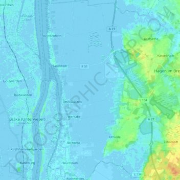
Name: Sandstedt topographic map, elevation, terrain.
Average elevation: 1 m
Minimum elevation: -6 m
Maximum elevation: 23 m
Make a donation
Gear up for your next adventure:
As an Amazon Associate, this site earns from qualifying purchases at no extra cost to you.
Other topographic maps
Click on a map to view its topography, its elevation and its terrain.
Dorfhagen
Deutschland > Niedersachsen > Landkreis Cuxhaven > Hagen im Bremischen
Average elevation: 15 m
Wittstedt
Deutschland > Niedersachsen > Landkreis Cuxhaven > Hagen im Bremischen
Average elevation: 5 m
Voßloge
Deutschland > Niedersachsen > Landkreis Cuxhaven > Hagen im Bremischen > Wulsbüttel
Average elevation: 20 m
Harrendorf
Deutschland > Niedersachsen > Landkreis Cuxhaven > Hagen im Bremischen > Bramstedt
Average elevation: 15 m
Make a donation
Gear up for your next adventure:
As an Amazon Associate, this site earns from qualifying purchases at no extra cost to you.
Siedlung Heuberg
Deutschland > Niedersachsen > Landkreis Cuxhaven > Hagen im Bremischen > Wulsbüttel
Average elevation: 13 m