Geolocate

Quintino topographic map

Click on the map to display elevation.

About this map
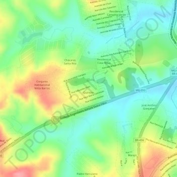
Name: Quintino topographic map, elevation, terrain.

Location: Quintino, Divinópolis, Região Geográfica Imediata de Divinópolis, Região Geográfica Intermediária de Divinópolis, Minas Gerais, Região Sudeste, Brasil (-20.16487 -44.93713 -20.15881 -44.92656)

Average elevation: 764 m

Minimum elevation: 722 m

Maximum elevation: 823 m

Other topographic maps

Click on a map to view its topography, its elevation and its terrain.

Lagoa

Brasil > Minas Gerais > Divinópolis

Average elevation: 771 m

Rio Itapecerica

Brasil > Minas Gerais > Divinópolis

Average elevation: 718 m

Buritis

Brasil > Minas Gerais > Divinópolis

Average elevation: 765 m

Morro da Pitimba

Brasil > Minas Gerais > Divinópolis

Average elevation: 724 m

Córrego Falso

Brasil > Minas Gerais > Divinópolis

Average elevation: 772 m

Gear up for your next adventure:

🧢Hiking Hat - Sun-protective and breathable hats for long treks
🔦LED Headtorch - Bright and durable light for night activities
🔦LED Flashlight - Powerful and long-lasting flashlight for camping and emergencies
☕Camping Coffee Maker - Brew fresh coffee anywhere on the topographic map
🧭GPS Outdoor Watch - Smart watch for navigation and fitness tracking in nature

As an Amazon Associate, this site earns from qualifying purchases at no extra cost to you.